
Reproducible Spectral-Spatial Vegetation Stratification from a Single Jilin-1 Scene under Controlled Validation
DOI:
https://doi.org/10.66279/x177jn35Keywords:
Spectral-Spatial, Jilin-1 Scene, Vegetation Mapping, Weak Supervision, Palm MonitoringAbstract
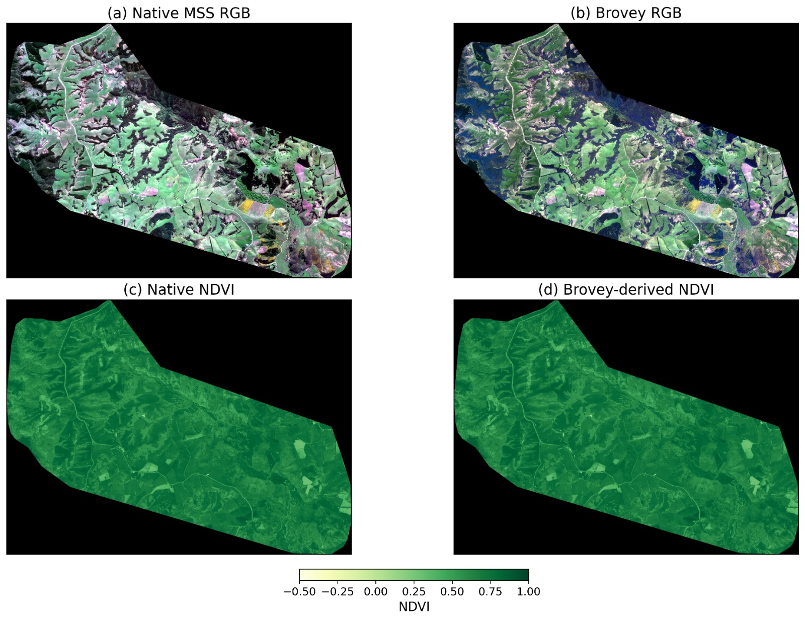
Very-high-resolution (VHR) satellite imagery may support individual palm delineation and field-calibrated assessment of vegetation condition, but such programs require costly multi-farm imagery, tree-level annotations, and field measurements. This study asks whether a single Jilin-1 scene, acquired on 6 October 2024, contains enough reproducible spectral-spatial structure to justify that investment. The scene serves only as a technical test bed because palm occurrence within it was not verified. An exploratory Stage 1 pipeline (Brovey preprocessing, four spectral indices, three-cluster MiniBatch K-Means pseudo-labels, and a U-Net) reached 0.9806 agreement with its own labels, but redundant features, whole-scene clustering, overlap between clustering features and model inputs, and reuse of validation data limited interpretation. A controlled Stage 2 removed an exact duplicate (green-NIR normalized contrast) and an algebraic duplicate (ratio vegetation index), clustered on NDVI and GNDVI, and selected two clusters from a five-seed analysis (silhouette 0.59472; pairwise adjusted Rand index 0.99034). Training, validation, and held-out test regions were separated by guard patches, and the scaler and clustering model were fitted on training data only. In the held-out region, a bands-only Logistic Regression reproduced the two-stratum reference with 0.99401 agreement, compared with 0.99192 ± 0.00153 for a bands-only U-Net over three seeds. The U-Net did not exceed Logistic Regression in agreement, although its macro-F1 and mean intersection over union were higher in point estimate. Supplying NDVI and GNDVI to the U-Net improved every metric, which provides direct evidence of target-feature overlap. The scene therefore contains strong, reproducible, scene-relative spectral structure that raw bands recover in a geographically separated region, and a deep network is not required for high pseudo-label reproduction. Because Brovey fusion degraded reduced-resolution radiometric fidelity, these results are conditional on that preprocessing choice. The strata are not validated indicators of moisture, stress, disease, or palm condition, and a multi-farm, multi-date study with palm annotations and field measurements remains necessary.
Downloads
References
[1] R. Al-Ruzouq, M. B. A. Gibril, A. Shanableh, J. Bolcek, F. Lamghari, N. A. Hammour, A. El-Keblawy, and R. Jena, “Spectral–spatial transformer-based semantic segmentation for large-scale mapping of individual date palm trees using very high-resolution satellite data,” Ecological Indicators, vol. 163, p. 112110, 2024.
[2] M. B. A. Gibril, H. Z. M. Shafri, A. Shanableh, R. Al-Ruzouq, S. J. bin Hashim, A. Wayayok, and M. S. Sachit, “Large scale assessment of date palm plantations based on uav remote sensing and multiscale vision transformer,” Remote Sensing Applications: Society and Environment, vol. 34, p. 101195, 2024.
[3] A. Hammadi, I. Mahi, H. Rhinane, M. Maanan, A. Zingraff-Hamed, and M. Maanan, “Deep learning for palm tree health assessment: UAV-based segmentation in the figuig region of morocco,” The International Archives of the Photogrammetry, Remote Sensing and Spatial Information Sciences, vol. XLVIII-4/W17-2025, pp. 169–181, 2026.
[4] S. Delalieux, T. Hardy, M. Ferry, S. Gomez, L. Kooistra, M. Culman, and L. Tits, “Red palm weevil detection in date palm using temporal uav imagery,” Remote Sensing, vol. 15, no. 5, 2023.
[5] J. Rouse, John W., R. H. Haas, J. A. Schell, and D. W. Deering, “Monitoring vegetation systems in the great plains with ERTS,” in Proceedings of the Third Earth Resources Technology Satellite-1 Symposium, vol. 1, (Washington, DC), pp. 309–317, National Aeronautics and Space Administration, 1974. NASA Special Publication SP-351.
[6] C. F. Jordan, “Derivation of leaf-area index from quality of light on the forest floor,” Ecology, vol. 50, no. 4, pp. 663–666, 1969.
[7] A. A. Gitelson, Y. J. Kaufman, and M. N. Merzlyak, “Use of a green channel in remote sensing of global vegetation from eos-modis,” Remote Sensing of Environment, vol. 58, no. 3, pp. 289–298, 1996.
[8] S. K. McFeeters, “The use of the normalized difference water index (ndwi) in the delineation of open water features,” International journal of remote sensing, vol. 17, no. 7, pp. 1425–1432, 1996.
[9] X. Lu, Z. Jiang, and H. Zhang, “Weakly supervised remote sensing image semantic segmentation with pseudo-label noise suppression,” IEEE Transactions on Geoscience and Remote Sensing, vol. 62, pp. 1–12, 2024.
[10] Z. Wang, H. Chang, L. Bai, L. Chen, and X. Bi, “A creative weak supervised semantic segmentation for remote sensing images,” IEEE Transactions on Geoscience and Remote Sensing, vol. 62, pp. 1–13, 2024.
[11] X. Xue, H. Zhu, X. Li, J. Wang, L. Qu, and B. Hou, “Egpo: Enhanced guidance and pseudo-label optimization for semi-supervised semantic segmentation of remote sensing images,” IEEE Transactions on Geoscience and Remote Sensing, vol. 63, pp. 1–13, 2025.
[12] D. R. Roberts, V. Bahn, S. Ciuti, M. S. Boyce, J. Elith, G. Guillera-Arroita, S. Hauenstein, J. J. Lahoz-Monfort, B. Schröder, W. Thuiller, D. I. Warton, B. A. Wintle, F. Hartig, and C. F. Dormann, “Cross-validation strategies for data with temporal, spatial, hierarchical, or phylogenetic structure,” Ecography, vol. 40, no. 8, pp. 913–929, 2017.
[13] R. Valavi, J. Elith, J. J. Lahoz-Monfort, and G. Guillera-Arroita, “blockcv: An R package for generating spatially or environmentally separated folds for k-fold cross-validation of species distribution models,” Methods in Ecology and Evolution, vol. 10, no. 2, pp. 225–232, 2019.
[14] G. Vivone, M. Dalla Mura, A. Garzelli, R. Restaino, G. Scarpa, M. O. Ulfarsson, L. Alparone, and J. Chanussot, “A new benchmark based on recent advances in multispectral pansharpening: Revisiting pansharpening with classical and emerging pansharpening methods,” IEEE Geoscience and Remote Sensing Magazine, vol. 9, no. 1, pp. 53–81, 2021.
[15] M. Ciotola, G. Guarino, and G. Scarpa, “An unsupervised cnn-based pansharpening framework with spectral-spatial fidelity balance,” Remote Sensing, vol. 16, no. 16, 2024.
[16] W. Kang, Y. Feng, Y. Ding, H. Xiang, X. Liu, and Y. Cai, “Hsstn: A hybrid spectral–structural transformer network for high-fidelity pansharpening,” Remote Sensing, vol. 17, no. 19, 2025.
[17] O. Ronneberger, P. Fischer, and T. Brox, “U-net: Convolutional networks for biomedical image segmentation,” in Medical Image Computing and Computer-Assisted Intervention – MICCAI 2015 (N. Navab, J. Hornegger, W. M. Wells, and A. F. Frangi, eds.), (Cham), pp. 234–241, Springer International Publishing, 2015.
[18] M. Tan and Q. Le, “Efficientnet: Rethinking model scaling for convolutional neural networks,” in Proceedings of the 36th International Conference on Machine Learning, vol. 97, pp. 6105–6114, PMLR, 2019.
[19] X. X. Zhu, D. Tuia, L. Mou, G.-S. Xia, L. Zhang, F. Xu, and F. Fraundorfer, “Deep learning in remote sensing: A comprehensive review and list of resources,” IEEE Geoscience and Remote Sensing Magazine, vol. 5, no. 4, pp. 8–36, 2017.
[20] N. A. A. Braham, C. M. Albrecht, J. Mairal, J. Chanussot, Y. Wang, and X. X. Zhu, “Spectralearth: Training hyperspectral foundation models at scale,” IEEE Journal of Selected Topics in Applied Earth Observations and Remote Sensing, vol. 18, pp. 16780–16797, 2025.
[21] F. Kruse, A. Lefkoff, J. Boardman, K. Heidebrecht, A. Shapiro, P. Barloon, and A. Goetz, “The spectral image processing system (sips)—interactive visualization and analysis of imaging spectrometer data,” Remote Sensing of Environment, vol. 44, no. 2, pp. 145–163, 1993. Airbone Imaging Spectrometry.
[22] L. Wald, “Quality of high resolution synthesised images: Is there a simple criterion?,” in Proceedings (T. Ranchin and L. Wald, eds.), (Sophia Antipolis, France), pp. 99–103, SEE/URISCA, 2000.
[23] D. Sculley, “Web-scale k-means clustering,” in Proceedings of the 19th International Conference on World Wide Web, pp. 1177–1178, ACM, 2010.
[24] F. Pedregosa, G. Varoquaux, A. Gramfort, V. Michel, B. Thirion, O. Grisel, M. Blondel, P. Prettenhofer, R. Weiss, V. Dubourg, J. Vanderplas, A. Passos, D. Cournapeau, M. Brucher, M. Perrot, and É. Duchesnay, “Scikit-learn: Machine learning in Python,” Journal of Machine Learning Research, vol. 12, no. 85, pp. 2825–2830, 2011.
[25] I. Loshchilov and F. Hutter, “Decoupled weight decay regularization,” in International Conference on Learning Representations, 2019.
[26] P. J. Rousseeuw, “Silhouettes: A graphical aid to the interpretation and validation of cluster analysis,” Journal of Computational and Applied Mathematics, vol. 20, pp. 53–65, 1987.
[27] L. J. Hubert and P. Arabie, “Comparing partitions,” Journal of Classification, vol. 2, pp. 193–218, 1985.
[28] H. R. Künsch, “The jackknife and the bootstrap for general stationary observations,” The Annals of Statistics, vol. 17, no. 3, pp. 1217–1241, 1989.
Downloads
Published
Data Availability Statement
This study used commercially supplied Jilin-1 imagery. The dataset is not publicly available because of applicable commercial and licensing restrictions but may be obtained from the corresponding author upon reasonable request, subject to the terms of the relevant data-use agreement.
Issue
Section
Categories
License
Copyright (c) 2026 The Authors

This work is licensed under a Creative Commons Attribution 4.0 International License.
Computational Discovery and Intelligent Systems (CDIS) seeks to publish the most influential papers that will significantly advance scientific understanding. Selected articles must present new and widely significant data, syntheses, or concepts. They should merit recognition by the wider scientific community and the general public through publication in a reputable scientific journal.
In addition to the content, this is published under a Creative Commons Attribution 4.0 International (CC BY 4.0) License. This means the content is freely available to all readers upon publication, and it is published as soon as production is complete.
SIRG Publisher